It is the day before New Years Eve and I was thinking about it and wondered how many countries see in the new year with fireworks, the answer is somewhere between 100 and 120, that’s more than I thought.
Some of the biggest firework displays take place in Sydney, London, Las Vegas and Ras Al Khaimah. Some sources say the biggest display is in Ras Al Khaimah.
The cost of the firework display in Sydney is around $6 million, I have no idea how much is spent in other places, but I expect it is a bloody lot.
Here people start finding their spot to watch them fireworks from early on in the day as many of the prime free vantage points officially open around 9am–10am, and people begin queueing before opening time. These spots often hit capacity by lunchtime. A couple of free places are Hickson Road Reserve opened at 9am and reached capacity just after 12:30pm another is Bennelong Lawn, Tarpeian Lawn, Campbells Cove, and Circular Quay also open around 9–9:30am and fill quickly.
Most areas with clear views of the Harbour Bridge or Opera House are already packed or close to it by 12pm–2pm.
If you arrive after 4pm, your chances of getting into a top-tier free spot (Opera House surrounds, Mrs Macquaries Point, Circular Quay) drop dramatically. Many will already be closed due to capacity.
Some vantage points (e.g., Opera House forecourt) are ticketed and sell out well in advance. These guarantee entry but still require arriving early for a good position.
You may be thinking why so early?
Sydney draws over one million people to the harbour foreshore each NYE. With limited space and strict entry controls (no re-entry, bag checks, alcohol restrictions), people settle in for the whole day.
So, what do people do while waiting, well some read, some play board games or listen to podcasts and some take a nap. Of course, people need to make sure they have food, water and sunscreen and some kind of shade gear.
Three countries that do not celebrate NYE are Iran as there New Year is in March, Afghanistan, Saudi Arabia, Yemen and Somala to name a few.
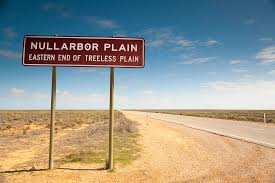
This week we are looking at the area of Australia called The Nullarbor Plain, which means “no trees” in Latin, is a vast, arid region in southern Australia with a rich history, both for Indigenous Australians and Europeans.
Historically, it was seasonally occupied by the Mirning and Yinyila Indigenous peoples, who knew it as Oondiri, meaning “waterless”.
Europeans first charted the coast in the 17th century, but the interior remained largely unexplored until Edward Eyre’s epic crossing in 1841. The Nullarbor has since been a site of pastoralism, railway construction, and even nuclear testing, shaping its modern landscape and infrastructure. They have a deep and continuing connection to the Nullarbor.
The name “Nullarbor” was coined by surveyor Edmund Delissern in1865. Pastoralists established stations along the telegraph and railway lines, and small settlements developed around these.
The Nullarbor was used for nuclear testing in the 1950s, leading to the displacement of Indigenous populations. The Trans-Australian Railway completed in 1917, facilitated travel and trade across the Nullarbor.
The Eyre Highway. A road across the Nullarbor, was completed in 1976, connecting South Australia and Western Australia. The highway is a 1,664-kilometre, it is signed as National Highways 1 and A1, it forms part of Highway 1 and the Australian National Highway network linking Perth and Adelaide.
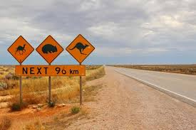
Driving directly across the Nullarbor Plain (from Norseman to Ceduna) takes approximately 12.5 hours of non-stop driving. However, most travellers allocate 2-3 days for the journey to allow for stops at attractions, wildlife viewing, and enjoying the scenery.
When driving across the Nullarbor people need to beware of trucks as there are triple-decker road trains which have brutal slipstreams, so slow down or pull over to let them pass. Also at night the road. turns into a marsupial rave party at night, from camels, kangaroos, dingoes and occasionally wombats. With no phone service, no other travellers, and emergency services hours away, getting into an accident could leave you stranded without help.
When camping Nullarbor, keep an eye out for scorpions, bird-eating spiders, eastern brown snakes, and death adders. Avoid setting up camp near bodies of water, high vegetation, rocks, fallen logs, or under trees. Also, remind curious kiddos that sticking hands in holes in the ground, under rocks, logs, or trees could disturb a creepy crawly!
If you run into trouble, do not leave your vehicle to search for help. Drones, planes, foot searches, and car trackers will see a vehicle and find you.
The area is known for its vast cave systems, some of which contain fossils and provide insights into the region’s past climate.
The Nullarbor continues to be a place of both natural beauty and human activity, with tourism and transport playing a significant role.
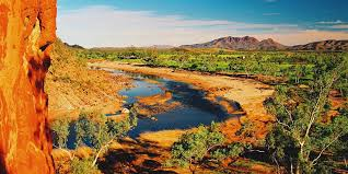
I have spent most of the day trying to decide what the topic of today’s post would be, and I ended up picking the town of Alice Springs.
Aussies commonly refer to Alice Springs as “The Alice” or simply “Alice”.
This is one town I would like to visit one day my parents visited the Alice and enjoyed the visit, I do remember mum & dad telling me that when the bought wine from a bottle shop, they were told to make sure it was covered so it couldn’t be seen by looking in a window and to get in their car and drive to a different area. This was because some of the local aboriginals would break into the car if they saw grog inside and if they were seen placing alcohol in the car and walking away the car would be broken into.
Alice Springs is a remote town in Australia’s Northern Territory, halfway between Darwin and Adelaide, both 1,500km away. It’s a popular gateway for exploring the Red Centre, the country’s interior desert region. Its 1872 origin as part of the Overland Telegraph Line (linking Darwin and Adelaide) is preserved in the vintage buildings and equipment at the Alice Springs Telegraph Station Historical Reserve.
It has an estimated population of around 28,922. This is based on the Alice Springs Town Council LGA profile, which was last updated in January 2025. The town is the major settlement in Central Australia and a significant population centre in the Northern Territory.
The population of Alice Springs is an estimate because it is based on projections and statistical modelling rather than a direct head count. The Australian Bureau of Statistics (ABS) uses various methods, including census data and estimated resident population (ERP) figures, to calculate population numbers, but these are subject to revision and may not perfectly reflect the actual population at any given time, especially in smaller areas like Alice Springs.
Alice Springs was established in 1872 with the construction of the Alice Springs Telegraph Station, part of the Australian Overland Telegraph Line (OTL) connecting Adelaide to Darwin. It was originally named Stuart, but the settlement near the telegraph station was later renamed Alice Springs in 1933. The name Alice Springs was given by W.W. Mills, after Alice Todd, wife of Sir Charles Todd, who was instrumental in the construction of the telegraph line.
The Arrernte people are the traditional owners and custodians of Alice Springs, also known as Mparntwe in the Arrernte language. They have a deep and enduring connection to the land, dating back tens of thousands of years. The Arrernte have stories and significant sites related to the creation of the landscape, including the MacDonnell Ranges.
Alice Springs is famous for its unique location in the heart of Australia, its strong Aboriginal culture and art scene, and its stunning natural landscapes, including the MacDonnell Ranges. It’s also known as a hub for exploring the broader Red Centre region and for its outback character.
Alice Springs faces a complex combination of social and crime-related issues that contribute to a perception of danger. These include high rates of alcohol-related violence, property crime, and domestic violence, along with concerns about youth crime and the impact of past policies. While the town has a diverse population and attracts tourists, these issues have led to increased fear and anxiety among residents.
While Alice Springs faces significant challenges, it’s important to acknowledge that it is also a place of cultural significance, with a diverse population and a strong community spirit. Efforts are underway to address the underlying issues and improve safety and well-being for all residents.
This week we are looking at the second largest city/town in South Australia, which is Mount Gambier, with a population of over 26,000. It is located on the Limestone Coast. It is in the southeastern corner of South Australia.
The town was founded by Hastings Cunningham and was first called “Gambierton” in 1854 by subdividing a block of 77 acres (31 ha). From 1861 to 1878, the Post Office was known by this name before reverting to Mount Gambier.
It’s known for its limestone, volcanic landscape and crater lakes. One of these, Blue Lake, turns cobalt blue in summer. Nearby, the Centenary Tower offers panoramic views of the area. The Umpherston Sinkhole contains a lush sunken garden. The Lady Nelson Visitor Centre houses a full-size replica of a late-18th-century ship.
Mount Gambier’s history is marked by its volcanic origins, early European exploration, and development as a significant regional centre in South Australia. The extinct volcano, Mount Gambier, was first sighted by Lieutenant James Grant in 1800 and named after Admiral James Gambier. European settlement began in the 1840s, with the area becoming a major agricultural and timber centre.
The traditional owners of the Mount Gambier area are the Boandik people, also known as the Bungandidj. They are the First Nations people of the region, and their language and culture are deeply connected to the land and waterways. The name “Bungandidj” is said to mean “people of the reeds”.
Organizations like the City of Mount Gambier and headspace Mount Gambier formally acknowledge the Boandik people as the traditional custodians.
There’s a growing movement to recognize the Boandik presence and connection to the land through dual naming of significant sites, alongside their European names.
The Bungandidj language is being revitalized, and efforts are underway to reintroduce it into the community.
The Boandik people have a long and rich history in the region, and their stories and cultural knowledge are important to the area’s identity.
Mount Gambier is generally considered a safe place, but like any location, it has areas where caution is advised, especially at night or in more remote areas. While some crime statistics show increases in thefts and break-ins, these are not indicative of the overall safety of the city for residents and visitors.
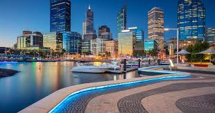
This week we are looking at the last of Australia’s capital cities and that city is Perth, capital of Western Australia. It sits where the Swan River meets the southwest coast. Sandy beaches line its suburbs, and the huge, riverside Kings Park and Botanic Garden on Mount Eliza offer sweeping views of the city. The Perth Cultural Centre houses the state ballet and opera companies, and occupies its own central precinct, including a theatre, library and the Art Gallery of Western Australia.
It was named after the Scottish city of Perth. The name was chosen by Governor Charles Fremantle, who was instructed by the British Secretary for the Colonies, Sir George Murray, who was a native of Perthshire, Scotland.
It was founded by Captain James Stirling as the capital of the Swan River Colony in 1829. It was the first free-settler colony in Australia established by private capital. From 1850, convicts began to arrive at the colony in large numbers to build roads and other public infrastructure.
The Traditional Owners of Perth are the Whadjuk Nyoongar people. They are part of the larger Noongar nation and have been the custodians of the land and waters for at least 45,000 years. The town recognizes the Whadjuk people as the Traditional Owners.
The river is a sacred place for Nyoongar peoples and they preserved many stories of the Waugal, a water-serpent understood to be responsible for the creation and maintenance of the river and most of the water features around Perth. The Nyoongar peoples moved with the seasons, travelling inland in winter, then returning in late spring to capture game such as wallabies, kangaroos and possums. A main camp site was at what is now known as Kings Park (Mooro Kaarta). Aboriginal peoples also frequented the mud flats (Matagarup) which later became Heirisson Island as it was a productive fishing spot.
The Nyoongar peoples had contact with various seafaring visitors including the Dutch and the French before the arrival of Captain James Stirling who colonised the region for the British in 1829. Relations between the settlers and the Aboriginal peoples were not always harmonious as the latter were dispossessed of their land and subjected to sometimes harsh and unsympathetic colonial rule. Fast forward to December 2009 when the State Government signed a framework agreement with the representative body, the South West Aboriginal and Land and Sea Council, aimed at resolving through negotiation six Nyoongar Native Title claims over Perth and the south-west of Western Australia. The city is working closely with its Aboriginal community to deliver 71 actions in the City’s Reflect Reconciliation Action Plan which aim to build respect, relationships and opportunity with the Aboriginal and Torres Strait Islander communities.
Since water transport was vital to communications in the new colony before roads were built, the meanderings of the Swan River determined the site of the first towns. Governor Stirling decided that the site for the colony’s capital would be sited on the river 18km from the sea port of Fremantle. On 12 August 1829 Mrs Helen Dance, wife of the commander of HMS Sulphur, drove an axe into a tree (near the current Perth Town Hall) to mark the colony’s foundation.
The city site was mid-way between the sea and the farming areas of the Upper Swan. However, the early years were difficult financially for the colony and in 1850 it was decided that convict labour would be beneficial in that regard. Between 1850 and 1868 almost 10,000 convicts were transported from Britain. Due to the influx of convicts, many public works were completed during the period from 1856-79, notably the Perth Town Hall. It was not until 1856 that Perth officially gained ‘city’ status when it was declared a Bishop’s See by Queen Victoria.
The first meeting of the Perth City Council was held on 10 December 1858. Rich gold discoveries in the Kalgoorlie region in the early 1890s brought a new era of prosperity for the city and many impressive buildings, some of which still grace the streets to this day. The city also experienced significant population growth. Representative government evolved in Western Australia in the second half of the 19th Century and in 1901 Western Australia federated with the other Australian States to form the Commonwealth of Australia. Perth experienced another mining boom in the 1960s and the wealth it generated could be evidenced by the city’s changing CBD skyline.
Perth became widely known as the City of Lights when U.S. astronaut John Glenn told the world he had seen the city’s lights during his historic orbit around the Earth in February 1962. There was also international attention on Perth later that year when the British Empire and Commonwealth Games were held in the city.
The City of Perth is the fastest growing local government area with a population approaching 20,000. It has ranked consistently among the Top 10 most liveable cities in the world, as surveyed by the highly regarded The Economist Intelligence Unit. Once again, wealth generated by the State’s natural resources is driving development of the city, with the difference being that many companies and businesses are choosing to make Perth their home.
This week we are looking at Hobart, which is the capital of Australia’s island state of Tasmania, sits on the River Derwent. It has a population of around 56,000.
Nearby is Battery Point, a historic district with narrow lanes and colonial-era cottages. The city’s backdrop is 1,270m-high Mount Wellington, with sweeping views, plus hiking and cycling trails.
Battery Point is Hobart’s first suburb, and widely regarded as the best-preserved colonial-era suburb in Australia.
The Muwinina people are the traditional owners of Hobart, Tasmania. They are one of the four distinct groups of Tasmanian Aboriginal people who lived in southern Tasmania, along with the Nuenonne, Mellukerdee, and Lyluequonny. The Muwinina were known as the “South East People”. The city of Hobart is situated on land that was once the domain of the Muwinina for thousands of years.
Hobart is Australia’s second-oldest capital city, it was founded in 1804 as a British penal colony, by Lt-Governor Collins. Initially named Hobart Town, it grew from a small settlement to a significant port, driven by industries like whaling and shipbuilding.
Hobart served as a penal colony, with a significant influx of convicts and a growing reliance on industries like whaling and shipbuilding.
In 1811 Governor Macquarie ordered a town plan for Hobart, which was developing rapidly, with hotels, shops, and other establishments.
The 1820s saw increased development with more efficient administrators and a growing number of free settlers and ex-convicts.
The town became a municipality in 1852 and in 1857 it was designated a secular city. It was in 1881 that the “Town” was formally dropped from its name, leaving it as simply “Hobart”.
Today, Hobart is a vibrant city with a thriving cultural scene, including the Museum of Old and New Art (MONA). It also boasts a dynamic food scene and the famous Salamanca Market.
Hobart is one of the best places to visit during Summer, with average temperatures ranging from 11.5 – 21°C (52.7 – 69.8°F). The months of January and February are also the driest, and beaches are warm enough to swim.
Autumn has many calm, sunny days, with average temperatures between 8.9 – 17.3°C (48 – 63.1°F). The city is blanketed in deep red and yellow hues as the trees begin to change.
During Winter the island feels the southerly winds from the Antarctic and experiences some of Australia’s coolest temperatures. Mount Wellington is dotted with snow and average daily temperatures range from 5 – 12.3°C (41 – 54.1°F). Overnight temperatures can drop as low as 3°C (37.4°F).
In Spring, average temperatures range from 7.8 – 16.9°C (46 – 62.4°F). This is the wettest time of year (168.7mm / 6.6 inches), however it should be noted that Hobart is Australia’s second-driest capital city (after Adelaide).
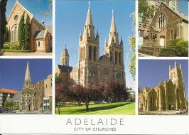
This week we are looking at the town of Adelaide the capital of South Australia, it has a population of around 1.4 million.
It is unique in Australia for being a planned city established as a free settlement, not a penal colony. Founded in 1836, it was named in honour of Adelaide of Saxe-Meiningen, wife of King William IV. The city’s layout, designed by Colonel William Light, features a grid pattern surrounded by parklands, making it a “city within a park”.
It was the first Australian city to be linked by telegraph to London (1872), and the first to allow women to vote (1895).
It is also known as the “City of Churches” due to the presence of numerous religious buildings.
The River Torrens, flowing through the city, played a significant role in its development and is a landmark feature. That being its ring of parkland on the River Torrens is home to renowned museums such as the Art Gallery of South Australia, displaying expansive collections including noted Indigenous art, and the South Australian Museum, devoted to natural history. The city’s Adelaide Festival is an annual international arts gathering with spin-offs including fringe and film events.
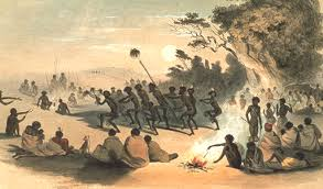
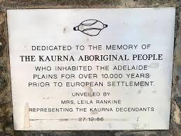
The traditional owners of the Adelaide region, specifically the Adelaide Plains, are the Kaurna people. They are recognized as the custodians of this land, with their traditional lands extending from Port Broughton to Cape Jervis. The City of Adelaide formally acknowledges the Kaurna people as the traditional owners and pays respect to their Elders, past and present.
The traditional Kaurna name for Adelaide is Tarntanya, which translates to “red kangaroo place”. The Kaurna people are the Traditional Owners of the Adelaide Plains, and Adelaide was their central gathering place and area of movement and activity. While the city of Adelaide is now known by its European name, the Kaurna name is increasingly recognized and used, particularly in signage and dual naming efforts.
So, what is the town known for well, its vibrant arts and cultural scene, particularly its extensive festival calendar. It’s also recognized for its high-quality education and beautiful natural landscapes, including beaches and wine regions. Furthermore, Adelaide is a city known for its charming architecture, exceptional coffee, and artisan produce.
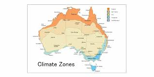
The Adelaide region has a Mediterranean climate, characterised with cold to mild wet winters and warm to hot dry summers. Most of the region’s rainfall occurs from mid-autumn to mid spring (April to October), which coincides with southern Australia’s wet season.
In May 1899, in a break with the common international practice of setting one-hour intervals between adjacent time zones, South Australia advanced Central Standard Time by thirty minutes after lobbying by businesses who wanted to be closer to Melbourne time and cricketers and footballers who wanted more daylight.
This week we are looking at the town of Melbourne. Greater Melbourne’s area of approximately 9900 km² of suburbs spread more than 40 km to the south, 30 km to the east, 20 km to the north and sprawl across vast, flat basalt plains to the west.
Melbourne is the coastal capital of the southeastern Australian state of Victoria. At the city’s centre is the modern Federation Square development, with plazas, bars, and restaurants by the Yarra River. In the Southbank area, the Melbourne Arts Precinct is the site of Arts Centre Melbourne – a performing arts complex – and the National Gallery of Victoria, with Australian and indigenous art.
Melbourne’s population is estimated to be around 5.39 million people.
Melbourne is situated on the traditional lands of the Wurundjeri Woi-wurrung and Bunurong Boon Wurrung peoples, part of the Eastern Kulin Nation. These First Nations peoples have a strong connection to the land, water, and community, and their history and culture are integral to Melbourne’s identity.
Melbourne has always been an important meeting place for events of social, educational, sporting, and cultural significance for the Wurundjeri Woi-wurrung and their Eastern Kulin neighbours.
The Wurundjeri and Bunurong peoples continue to have a strong connection to their land, water, and community, and they are actively involved in cultural preservation and community engagement.
Melbourne offers opportunities for visitors to learn about and experience Aboriginal culture through organizations like the Koorie Heritage Trust, Museums Victoria (Bunjilaka), and other cultural initiatives.
Melbourne has a temperate oceanic climate, also known as a mild temperate climate. This means it experiences warm summers, cool winters, and relatively consistent rainfall throughout the year. It’s also known for its unpredictable weather, with locals often saying they can experience four seasons in a single day.
The town’s location on the coast and its proximity to the Southern Ocean contribute to its changeable weather. It’s also located on the boundary of hot inland areas and the cool Southern Ocean, which further contributes to its unpredictable conditions.
Melbourne is widely known for its vibrant street art, bustling laneways, world-class coffee culture, diverse culinary scene, and thriving arts and culture scene. It’s also renowned as a major sporting city, hosting major events like the Australian Open and Australian Grand Prix. Additionally, Melbourne is recognized for its liveability and multiculturalism, making it a popular destination for both residents and visitors.
Melbourne’s history begins with its founding in 1835 by settlers from Tasmania who established a settlement on the Yarra River. The city was named in honour of the British Prime Minister, William Lamb, 2nd Viscount Melbourne. Melbourne experienced significant growth due to the 1850s Gold Rush, which brought in a large influx of people and fuelled economic prosperity.
In the 1850’s the discovery of gold in the region led to the Gold Rush, dramatically transforming Melbourne into a bustling metropolis. The city’s population quadrupled, reaching 80,000 within three years.
In 1851 Victoria separated from New South Wales and became a separate colony, with Melbourne as its capital.
Between 1850 and 1880 Melbourne became a major trading and industrial centre, with the development of infrastructure like railways and the Melbourne Harbour Trust. During 1901 and 1927 Melbourne served as the seat of government for the Commonwealth of Australia.
Melbourne hosted the Summer Olympics in 1956, becoming the first city outside of Europe and North America to do so.
During the 1990’s and 2000’s Melbourne continued to evolve, with the development of major infrastructure projects like CityLink and the construction of Federation Square.
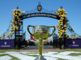
Melbourne is also famous for The Melbourne Cup which is a horse race held on the first Tuesday in November. It is an annual race held at the Flemington Racecourse. It is the richest two-mile handicup in the world and one of the richest turf races. The event starts at 3:00 pm on the first Tuesday of November and is known locally as “the race that stops the nation”.
The Melbourne Cup has cemented itself as a part of Melbourne and Australian culture, having been run every year since 1861 except for an intermission during both World Wars.
The day of the race has been a public holiday for much of Victoria since 1876.
This week we are looking at the town of Darwin which is the capital of the Northern Territory and has been since 1911 when the area was transferred from South Australia to the Commonwealth of Australia. The handover also included a renaming of the city from Palmerston to Darwin. Darwin was also given city status in 1959. It was a former frontier outpost.
The traditional owners of Darwin are the Larrakia (saltwater) people. Larrakia country runs far beyond the municipal boundaries of Darwin, covering the area from the Cox Peninsula in the west to the Adelaide River in the east. The Larrakia people established the first trade routes in the region, trading with the Tiwi, Wagait, and Wulna people as well as with Indonesian fishermen. Their stories, songs, and ceremonies echo the strong connection and understanding they have with the saltwater country.
Darwin is a gateway to massive Kakadu National Park. Its popular waterfront area has several beaches and green areas like Bicentennial Park. Also near the water is the Museum and Art Gallery of the Northern Territory, displaying Southeast Asian and Pacific art, plus a pearling lugger and other seafaring vessels.
In 1839, the HMS Beagle with Lt. John Lort Stokes aboard sailed into the waters of what is now known as Darwin harbour. Stokes named the harbour after his former shipmate British evolutionist Charles Darwin but contrary to popular rumours, Darwin himself never visited the area.
Darwin was originally founded as Palmerston in 1869, although the port was always known as Port Darwin. The town’s growth was accelerated when gold was discovered at Pine Creek in 1871.
In 1939 a Darwin Town Management Board was formed comprising three Commonwealth Government officers and a Citizens’ Advisory Committee. However, it ceased when Darwin was bombed during World War II.
Between February 1942 and October 1943, the Japanese launched more than 60 air raids over Darwin.
Since the early 1960s, Council has hosted a service on 19 February to commemorate the Bombing of Darwin. In 2011, the Governor General of Australia officially declared the 19 February ‘Bombing of Darwin Day – A National Day of Observance’.
When Darwin returned to civilian control after the war, a new Town Management Board was formed comprising officials and a representative group of residents.
On 1 July 1957 the people of Darwin elected for the first time a Mayor and 12 Councillors. There was much enthusiasm at the time for granting of self-governance with a voter turnout of more than 85 per cent on Election Day, 29 June 1957. Council’s first elected Mayor was Lucius (Bill) Richardson.
In May 1975, Darwin elected its first female Mayor, Dr Ella Stack, who also played a strong role in the Darwin Reconstruction Committee.
In 1978 the Commonwealth passed The Northern Territory (Self Government) Act 1978 establishing the Northern Territory as a distinct political entity under the Crown, with limited state-like powers, effective on 1 July 1978.
In November 1979 Dr Stack became Darwin’s first Lord Mayor.
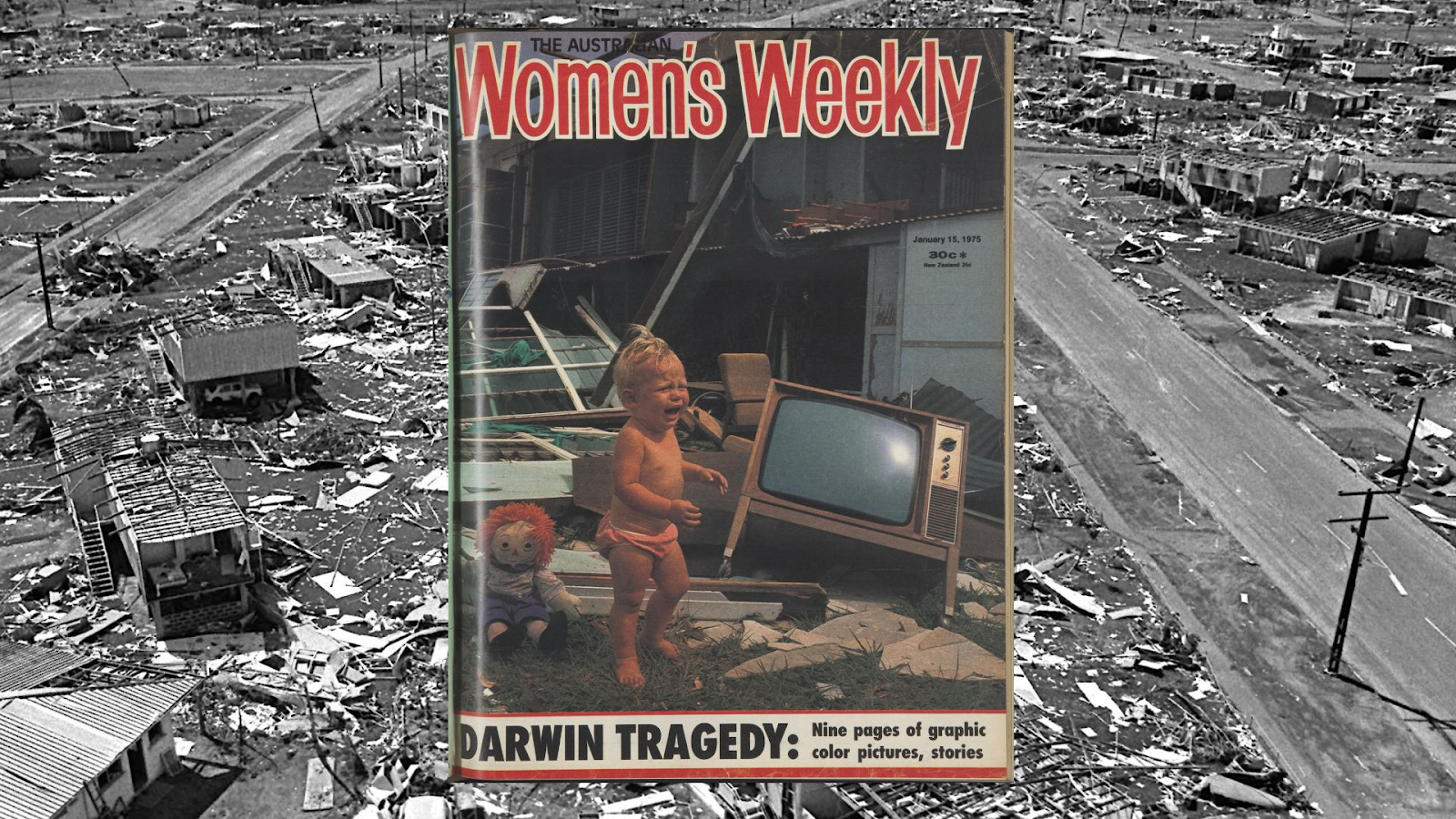
Darwin was the scene of the biggest airlift in Australian history after Cyclone Tracy devastated the city in the early hours of Christmas Day 1974. Cyclone Tracy killed 66 people and injured thousands more. Many of those who died or were injured were struck by flying debris.
More than 30,000 of the city’s then 43,000 people were evacuated to cities and towns all over Australia immediately after the devastation of Tracy. But for many Darwin was a hard place to stay away from and people returned to resume their lives in the capital city of the Northern Territory. After the cyclone, the Darwin Reconstruction Commission (DRC), made up of Federal, Territory, and Local Government representatives, was involved with the running and rebuilding of the city which gradually turned Darwin into the most modern capital city in the nation.
The estimated usual resident population of Greater Darwin in 2021 was 139,902. This makes Darwin Australia’s smallest capital city. The city has nearly 53% of the Northern Territory’s population.
This week we are looking at Sydney, which is the capital of New South Wales and one of Australia’s largest cities, is best known for its harbourfront Sydney Opera House, with a distinctive sail-like design. Massive Darling Harbour and the smaller Circular Quay port are hubs of waterside life, with the arched Harbour Bridge and esteemed Royal Botanic Garden nearby. Sydney Tower’s outdoor platform, the Skywalk, offers 360-degree views of the city and suburbs.
The estimated population of the Sydney metropolitan area in 2025 is around 5.248 million.
Greater Sydney covers 12,368.7 sq km and is made up of 34 local councils. Over 650 suburbs make up the Greater Sydney region.
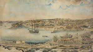
Sydney was founded 237yrs ago when in 1788, the First Fleet of convicts, led by Arthur Phillip, founded Sydney as a British penal colony, making it the first European settlement in Australia.
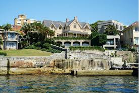
Sydney is also where Kirribilli House is, this is the secondary official residence of the prime minister of Australia. Located in the Northern Sydney suburb of Kirribilli, New South Wales, the cottage and its associated grounds are located at the far eastern end of Kirribilli Avenue.
It commands impressive views across to the Sydney Harbour Bridge, Circular Quay and the Sydney Opera House and has been visited over the years by many important international dignitaries. Kirribilli House is open to the public on one day a year, courtesy of The Australiana Fund.
This year it will be open to the public for an open day on Saturday, June 3rd, 2025, from 10:00 am to 2:00 pm, along with Admiralty House, allowing visitors to explore the grounds and gardens.
There will be tours of both houses, and then lunch on the lawns. You can bring a packed lunch, or there will be food available to purchase. Entry is $15.
Sydney has relatively low crime rates compared to many other major cities globally. Violent crime is uncommon, and the city is known for its safe streets.
Sydney’s public transportation system, including buses, trains, and ferries, is generally safe and mostly reliable all the services are well-monitored and have security measures in place. We also have transit officers that can tell people to leave stations and trains, demand full name and residential address when they suspect, on reasonable grounds that a person has committed a railway offence, Issue infringement notices (‘on-the-spot’ fines) for railway offences.